|
|
| Mesoscale Discussion 100 | |
| Next MD > | |
|
|
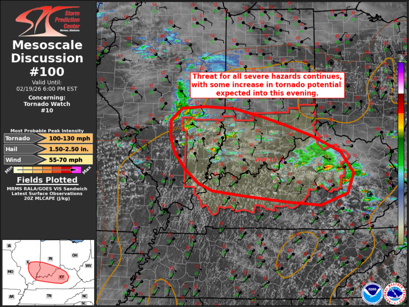
Mesoscale Discussion 0100 NWS Storm Prediction Center Norman OK 0256 PM CST Thu Feb 19 2026 Areas affected...portions of southeastern Illinois...southern Indiana...and northern Kentucky Concerning...Tornado Watch 10... Valid 192056Z - 192300Z The severe weather threat for Tornado Watch 10 continues. SUMMARY...Storm intensity will continue to gradually increase over the next 1-2 hours with additional development expected across the watch area. Modest buoyancy and favorable shear profiles will continue to support a threat for all severe hazards across WW0010, with some increase in tornado potential expected into this evening. DISCUSSION...Thunderstorms have gradually increased in coverage over the past 1-2 hours, primarily over northern/central Kentucky, with several discrete/semi-discrete supercells noted across the area. While only a few isolated instances of marginally severe hail have been noted thus far, gradual strengthening has been observed with some cells as surface heating/moistening coupled with cold temperatures aloft has yielded a modestly unstable air mass (MLCAPE of 500-1000 J/kg) overlapped by favorable deep layer shear profiles (effective bulk shear of 50+ kts). Farther west, latest guidance continues to depict additional thunderstorm development and strengthening across the western portions of the watch area. As storms continue to strengthen, all severe hazards will be possible, with steep mid-level lapse rates and elongated hodographs supporting the threat for large hail and favorable low-level veering wind profiles (0-1 km SRH of 100-150+ m2/s2 per regional VWP) supporting a risk for tornadoes. While the gradual loss of diurnal heating is expected to contribute to low-level stabilization with time later this evening, strengthening flow is expected to support additional increases to low-level hodograph curvature. The favorable shear profiles and increasing SRH will support an increasing tornado threat over the next couple of hours, with the potential for a strong tornado or two. ..Chalmers/Mosier.. 02/19/2026 ...Please see www.spc.noaa.gov for graphic product... ATTN...WFO...JKL...ILN...LMK...IND...PAH...ILX...LSX... LAT...LON 38388901 38748914 39158914 39428881 39488813 39438725 39228630 39058575 38948538 38798494 38418408 37918370 37448389 37178469 37248566 37408700 37508788 37688830 38008869 38388901 MOST PROBABLE PEAK TORNADO INTENSITY...100-130 MPH MOST PROBABLE PEAK WIND GUST...55-70 MPH MOST PROBABLE PEAK HAIL SIZE...1.50-2.50 IN |
|
|
Top/All Mesoscale Discussions/Forecast Products/Home |
|