
|
|
| Mesoscale Discussion 2003 | |
|
|
Mesoscale Discussion 2003
NWS Storm Prediction Center Norman OK
1152 AM CDT Fri Aug 22 2025
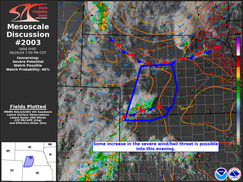
Areas affected...Far eastern Minnesota into northern Wisconsin and
the western Upper Peninsula of Michigan
Concerning...Severe potential...Watch unlikely
Valid 221652Z - 221845Z
Probability of Watch Issuance...20 percent
SUMMARY...Thunderstorm clusters developing across northern Wisconsin
may pose a localized severe hail/wind risk through the afternoon as
they spread east into the Upper Peninsula of Michigan. Watch
issuance is currently not anticipated, but trends will be monitored.
DISCUSSION...Thunderstorms developing along a surface cold front
across far eastern MN and northwest WI have shown signs of gradual
intensification per MRMS and GOES IR imagery. While stronger
mid/upper-level flow will likely remain displaced to the
north/northwest, recent VWP observations from KDLH sampled 0-6 km
BWD values on the order of 25-30 knots. This may promote some degree
of organization of embedded cells within the larger cluster through
early afternoon and cold pool consolidation/organization by mid/late
afternoon. Muted daytime heating of a seasonably moist air mass in
place downstream ahead of the front should promote a modest increase
in MLCAPE to around 1500 J/kg by mid-afternoon, which may also
bolster convective intensity to some degree.
In general, the expectation is that this activity will pose a threat
for isolated hail and perhaps isolated to scattered damaging/severe
gusts. There is some potential that a more widespread damaging wind
threat could emerge if convective intensity/organization is more
substantial than currently anticipated as hinted by a few morning
CAM solutions. This scenario could warrant a targeted watch issuance
later this afternoon, but based on current observations (ongoing
cloud cover, delayed surface heating, etc...), this potential seems
low.
..Moore/Gleason.. 08/22/2025
...Please see www.spc.noaa.gov for graphic product...
ATTN...WFO...MQT...GRB...DLH...MPX...
LAT...LON 46928988 47008938 46948915 46738878 46368856 45978854
45638862 45478902 45369271 45519319 45709343 46039340
46339293 46509196 46669115 46928988
MOST PROBABLE PEAK WIND GUST...UP TO 60 MPH
MOST PROBABLE PEAK HAIL SIZE...UP TO 1.25 IN
|
|
|
Top/All Mesoscale Discussions/Forecast Products/Home |
|