
|
|
| Mesoscale Discussion 849 | |
|
|
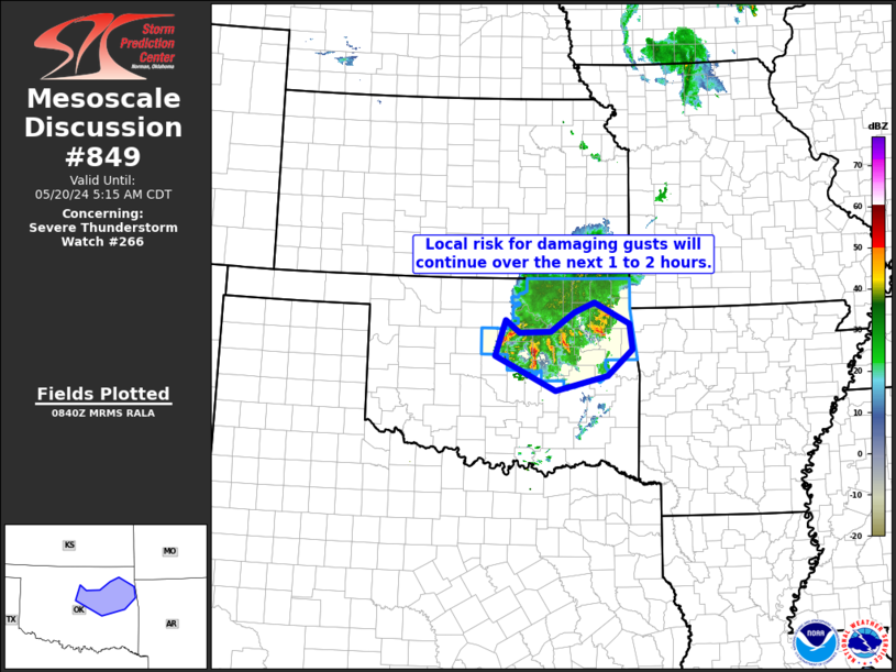
Mesoscale Discussion 0849 NWS Storm Prediction Center Norman OK 1130 PM CDT Sat May 17 2025 Areas affected...Oklahoma Concerning...Severe Thunderstorm Watch 283... Valid 180430Z - 180630Z The severe weather threat for Severe Thunderstorm Watch 283 continues. SUMMARY...A severe threat will likely continue across much of Oklahoma for several more hours. Very large hail, wind damage and an isolated tornado threat will be possible. DISCUSSION...The latest hi-resolution radar data from KTLX shows three areas of somewhat widely spaced severe storms. The most intense convection is located in western Oklahoma, along the eastern edge of a bullseye of moderate instability. The RAP has MLCAPE estimated in the 2000 to 3500 J/kg range, which appears to be related to a localized maximum in surface dewpoints. The storms are being supported by increasing low-level warm advection and to subtle perturbations within within west-southwesterly flow. The storms will continue to move eastward across central and eastern Oklahoma during the early overnight period. Regional WSR-88D VWPs at Oklahoma City and Tulsa have 0-6 km shear of 52 kt and 42 kt, respectively. The RAP is showing mid-level lapse rates above 8 C/km across much of central Oklahoma. This will support supercells with large hail. The most intense storms could also produce hailstones greater than 2 inches in diameter. An isolated wind-damage and tornado threat may also accompany the stronger storms. ..Broyles.. 05/18/2025 ...Please see www.spc.noaa.gov for graphic product... ATTN...WFO...TSA...OUN... LAT...LON 34579644 34599806 34869881 35709901 36369836 36299590 35559537 34849571 34579644 MOST PROBABLE PEAK TORNADO INTENSITY...100-130 MPH MOST PROBABLE PEAK WIND GUST...55-70 MPH MOST PROBABLE PEAK HAIL SIZE...1.50-2.50 IN |
|
|
Top/All Mesoscale Discussions/Forecast Products/Home |
|