
|
|
| Mesoscale Discussion 555 | |
|
|
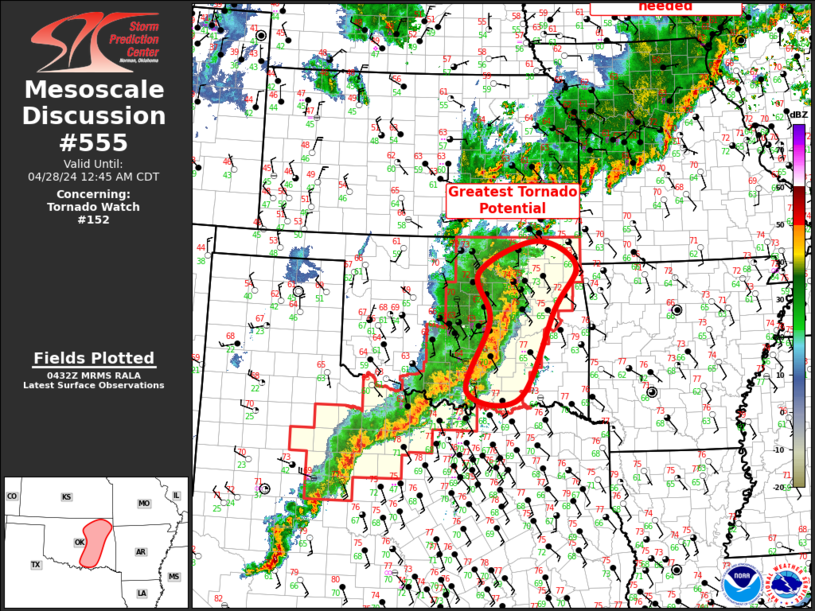
Mesoscale Discussion 0555 NWS Storm Prediction Center Norman OK 1151 PM CDT Thu Apr 24 2025 Areas affected...Parts of the TX Panhandle into western/central/northeast OK Concerning...Severe Thunderstorm Watch 171... Valid 250451Z - 250615Z The severe weather threat for Severe Thunderstorm Watch 171 continues. SUMMARY...Some severe threat will persist into the overnight hours. DISCUSSION...Three long-lived supercells are ongoing late tonight across the northeast TX Panhandle, while convection in OK has evolved into more of a quasi-linear mode, though a couple of embedded supercells persist across western OK. While MLCINH is increasing region-wide, the best relative storm environment remains across the TX Panhandle into extreme western OK, where MLCAPE in excess of 1500 J/kg and favorable deep-layer shear will continue to support supercell potential into the overnight hours. While ongoing storms will struggle to remain surface-based with time, a substantial nocturnal strengthening of the low-level jet (as noted on the KAMA VWP) may support some tornado potential with ongoing supercells in the short term. Otherwise, large hail and localized severe gusts will remain a threat for as long as vigorous convection persists overnight. Farther northeast, a small bowing segment has evolved across north-central OK, which is moving eastward along a weak surface boundary. The longevity of this bowing segment may be limited by diminishing downstream instability and increasing MLCINH, but a severe-wind threat could reach portions of northeast OK with time overnight. ..Dean.. 04/25/2025 ...Please see www.spc.noaa.gov for graphic product... ATTN...WFO...TSA...OUN...AMA... LAT...LON 35920128 35779951 36199798 36549747 36599668 36279616 35869621 35429676 35109813 34869967 34860029 34930107 35000139 35250152 35770162 35920128 MOST PROBABLE PEAK TORNADO INTENSITY...85-115 MPH MOST PROBABLE PEAK WIND GUST...65-80 MPH MOST PROBABLE PEAK HAIL SIZE...1.50-2.50 IN |
|
|
Top/All Mesoscale Discussions/Forecast Products/Home |
|