Note:
The expiration time in the watch graphic is amended if the watch is
replaced, cancelled or extended. Note: Click for Watch Status Reports.
SEL4
URGENT - IMMEDIATE BROADCAST REQUESTED
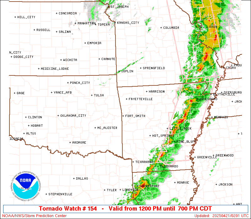
Tornado Watch Number 154
NWS Storm Prediction Center Norman OK
1200 PM CDT Sun Apr 20 2025
The NWS Storm Prediction Center has issued a
* Tornado Watch for portions of
western and central Arkansas
southeastern Kansas
northwestern Louisiana
central and southern Missouri
eastern Oklahoma
far northeastern Texas
* Effective this Sunday afternoon and evening from NOON until 700
PM CDT.
* Primary threats include...
Several tornadoes likely with a couple intense tornadoes
possible
Scattered damaging wind gusts to 70 mph likely
Scattered large hail events to 1.5 inches in diameter possible
SUMMARY...A steady increase in coverage and intensity of
thunderstorms is expected to occur over the next several hours, with
severe-weather potential evolving from eastern Oklahoma and the
Arklatex region northward into Missouri. Along with risk for fairly
widespread damaging wind gusts and hail, several tornadoes are
expected -- including potential for a few that are
strong/longer-lived.
The tornado watch area is approximately along and 75 statute miles
east and west of a line from 45 miles north of Springfield MO to 25
miles west of Texarkana AR. For a complete depiction of the watch
see the associated watch outline update (WOUS64 KWNS WOU4).
PRECAUTIONARY/PREPAREDNESS ACTIONS...
REMEMBER...A Tornado Watch means conditions are favorable for
tornadoes and severe thunderstorms in and close to the watch
area. Persons in these areas should be on the lookout for
threatening weather conditions and listen for later statements
and possible warnings.
&&
AVIATION...Tornadoes and a few severe thunderstorms with hail
surface and aloft to 1.5 inches. Extreme turbulence and surface wind
gusts to 60 knots. A few cumulonimbi with maximum tops to 500. Mean
storm motion vector 23040.
...Goss
   SEL4

   URGENT - IMMEDIATE BROADCAST REQUESTED
   Tornado Watch Number 154
   NWS Storm Prediction Center Norman OK
   1200 PM CDT Sun Apr 20 2025

   The NWS Storm Prediction Center has issued a

   * Tornado Watch for portions of
     western and central Arkansas
     southeastern Kansas
     northwestern Louisiana
     central and southern Missouri
     eastern Oklahoma
     far northeastern Texas

   * Effective this Sunday afternoon and evening from NOON until 700
     PM CDT.

   * Primary threats include...
     Several tornadoes likely with a couple intense tornadoes
       possible
     Scattered damaging wind gusts to 70 mph likely
     Scattered large hail events to 1.5 inches in diameter possible

   SUMMARY...A steady increase in coverage and intensity of
   thunderstorms is expected to occur over the next several hours, with
   severe-weather potential evolving from eastern Oklahoma and the
   Arklatex region northward into Missouri.  Along with risk for fairly
   widespread damaging wind gusts and hail, several tornadoes are
   expected -- including potential for a few that are
   strong/longer-lived.

   The tornado watch area is approximately along and 75 statute miles
   east and west of a line from 45 miles north of Springfield MO to 25
   miles west of Texarkana AR. For a complete depiction of the watch
   see the associated watch outline update (WOUS64 KWNS WOU4).

   PRECAUTIONARY/PREPAREDNESS ACTIONS...

   REMEMBER...A Tornado Watch means conditions are favorable for
   tornadoes and severe thunderstorms in and close to the watch
   area. Persons in these areas should be on the lookout for
   threatening weather conditions and listen for later statements
   and possible warnings.

   &&

   AVIATION...Tornadoes and a few severe thunderstorms with hail
   surface and aloft to 1.5 inches. Extreme turbulence and surface wind
   gusts to 60 knots. A few cumulonimbi with maximum tops to 500. Mean
   storm motion vector 23040.

   ...Goss
Note:
The Aviation Watch (SAW) product is an approximation to the watch area.
The actual watch is depicted by the shaded areas.
   SAW4
   WW 154 TORNADO AR KS LA MO OK TX 201700Z - 210000Z
   AXIS..75 STATUTE MILES EAST AND WEST OF LINE..
   45N SGF/SPRINGFIELD MO/ - 25W TXK/TEXARKANA AR/
   ..AVIATION COORDS.. 65NM E/W /31N SGF - 19W TXK/
   HAIL SURFACE AND ALOFT..1.5 INCHES. WIND GUSTS..60 KNOTS.
   MAX TOPS TO 500. MEAN STORM MOTION VECTOR 23040.

   LAT...LON 37869201 33439313 33439573 37869475

   THIS IS AN APPROXIMATION TO THE WATCH AREA.  FOR A
   COMPLETE DEPICTION OF THE WATCH SEE WOUS64 KWNS
   FOR WOU4.
Watch 154 Status Report Messages:
STATUS REPORT #3 ON WW 154

VALID 202250Z - 202340Z

SEVERE WEATHER THREAT CONTINUES RIGHT OF A LINE FROM 15 SW TXK TO
20 N HOT TO 15 ENE TBN.

FOR ADDITIONAL INFORMATION SEE MESOSCALE DISCUSSION 506

..SQUITIERI..04/20/25

ATTN...WFO...LZK...TSA...SHV...SGF...EAX...LSX...

&&

STATUS REPORT FOR WT 154

SEVERE WEATHER THREAT CONTINUES FOR THE FOLLOWING AREAS

ARC005-019-023-027-029-039-045-049-051-053-057-059-061-065-073-
089-091-099-103-105-109-119-125-129-137-141-202340-

AR
.    ARKANSAS COUNTIES INCLUDED ARE

BAXTER		     CLARK		 CLEBURNE
COLUMBIA	     CONWAY		 DALLAS
FAULKNER	     FULTON		 GARLAND
GRANT		     HEMPSTEAD		 HOT SPRING
HOWARD		     IZARD		 LAFAYETTE
MARION		     MILLER		 NEVADA
OUACHITA	     PERRY		 PIKE
PULASKI 	     SALINE		 SEARCY
STONE		     VAN BUREN
$$


LAC015-017-119-202340-

LA
.    LOUISIANA PARISHES INCLUDED ARE

BOSSIER 	     CADDO		 WEBSTER
$$


MOC007-027-065-067-091-125-137-149-151-153-161-169-173-203-215-
202340-

MO
.    MISSOURI COUNTIES INCLUDED ARE

AUDRAIN 	     CALLAWAY		 DENT
DOUGLAS 	     HOWELL		 MARIES
MONROE		     OREGON		 OSAGE
OZARK		     PHELPS		 PULASKI
RALLS		     SHANNON		 TEXAS
$$


TXC037-067-203-315-202340-

TX
.    TEXAS COUNTIES INCLUDED ARE

BOWIE		     CASS		 HARRISON
MARION
$$


THE WATCH STATUS MESSAGE IS FOR GUIDANCE PURPOSES ONLY.  PLEASE
REFER TO WATCH COUNTY NOTIFICATION STATEMENTS FOR OFFICIAL
INFORMATION ON COUNTIES...INDEPENDENT CITIES AND MARINE ZONES
CLEARED FROM SEVERE THUNDERSTORM AND TORNADO WATCHES.
$$

STATUS REPORT #2 ON WW 154

VALID 202025Z - 202140Z

SEVERE WEATHER THREAT CONTINUES RIGHT OF A LINE FROM 35 S PRX TO
25 WSW DEQ TO 20 NNE DEQ TO 30 ESE RKR TO 5 N FYV TO 15 WNW UMN
TO 30 SE OJC.

..WENDT..04/20/25

ATTN...WFO...LZK...TSA...SHV...SGF...EAX...LSX...

&&

STATUS REPORT FOR WT 154

SEVERE WEATHER THREAT CONTINUES FOR THE FOLLOWING AREAS

ARC005-009-015-019-023-027-029-039-045-047-049-051-053-057-059-
061-065-071-073-081-083-087-089-091-097-099-101-103-105-109-113-
115-119-125-127-129-133-137-141-149-202140-

AR
.    ARKANSAS COUNTIES INCLUDED ARE

BAXTER		     BOONE		 CARROLL
CLARK		     CLEBURNE		 COLUMBIA
CONWAY		     DALLAS		 FAULKNER
FRANKLIN	     FULTON		 GARLAND
GRANT		     HEMPSTEAD		 HOT SPRING
HOWARD		     IZARD		 JOHNSON
LAFAYETTE	     LITTLE RIVER	 LOGAN
MADISON 	     MARION		 MILLER
MONTGOMERY	     NEVADA		 NEWTON
OUACHITA	     PERRY		 PIKE
POLK		     POPE		 PULASKI
SALINE		     SCOTT		 SEARCY
SEVIER		     STONE		 VAN BUREN
YELL
$$


LAC015-017-119-202140-

LA
.    LOUISIANA PARISHES INCLUDED ARE

BOSSIER 	     CADDO		 WEBSTER
$$


MOC007-009-015-019-027-029-039-041-043-051-053-057-059-065-067-
077-083-085-089-091-105-109-121-125-131-135-137-141-149-151-153-
159-161-167-169-173-175-185-195-203-209-213-215-225-229-
202140-

MO
.    MISSOURI COUNTIES INCLUDED ARE

AUDRAIN 	     BARRY		 BENTON
BOONE		     CALLAWAY		 CAMDEN
CEDAR		     CHARITON		 CHRISTIAN
COLE		     COOPER		 DADE
DALLAS		     DENT		 DOUGLAS
GREENE		     HENRY		 HICKORY
HOWARD		     HOWELL		 LACLEDE
LAWRENCE	     MACON		 MARIES
MILLER		     MONITEAU		 MONROE
MORGAN		     OREGON		 OSAGE
OZARK		     PETTIS		 PHELPS
POLK		     PULASKI		 RALLS
RANDOLPH	     ST. CLAIR		 SALINE
SHANNON 	     STONE		 TANEY
TEXAS		     WEBSTER		 WRIGHT
$$


OKC089-202140-

OK
.    OKLAHOMA COUNTIES INCLUDED ARE

MCCURTAIN
$$


TXC037-067-203-315-387-202140-

TX
.    TEXAS COUNTIES INCLUDED ARE

BOWIE		     CASS		 HARRISON
MARION		     RED RIVER
$$


THE WATCH STATUS MESSAGE IS FOR GUIDANCE PURPOSES ONLY.  PLEASE
REFER TO WATCH COUNTY NOTIFICATION STATEMENTS FOR OFFICIAL
INFORMATION ON COUNTIES...INDEPENDENT CITIES AND MARINE ZONES
CLEARED FROM SEVERE THUNDERSTORM AND TORNADO WATCHES.
$$

STATUS REPORT #1 ON WW 154

VALID 201830Z - 201940Z

THE SEVERE WEATHER THREAT CONTINUES ACROSS THE ENTIRE WATCH AREA.

..WENDT..04/20/25

ATTN...WFO...LZK...TSA...SHV...SGF...EAX...LSX...

&&

STATUS REPORT FOR WT 154

SEVERE WEATHER THREAT CONTINUES FOR THE FOLLOWING AREAS

ARC005-007-009-015-019-023-027-029-033-039-045-047-049-051-053-
057-059-061-065-071-073-081-083-087-089-091-097-099-101-103-105-
109-113-115-119-125-127-129-131-133-137-141-143-149-201940-

AR
.    ARKANSAS COUNTIES INCLUDED ARE

BAXTER		     BENTON		 BOONE
CARROLL 	     CLARK		 CLEBURNE
COLUMBIA	     CONWAY		 CRAWFORD
DALLAS		     FAULKNER		 FRANKLIN
FULTON		     GARLAND		 GRANT
HEMPSTEAD	     HOT SPRING 	 HOWARD
IZARD		     JOHNSON		 LAFAYETTE
LITTLE RIVER	     LOGAN		 MADISON
MARION		     MILLER		 MONTGOMERY
NEVADA		     NEWTON		 OUACHITA
PERRY		     PIKE		 POLK
POPE		     PULASKI		 SALINE
SCOTT		     SEARCY		 SEBASTIAN
SEVIER		     STONE		 VAN BUREN
WASHINGTON	     YELL
$$


KSC011-021-037-107-201940-

KS
.    KANSAS COUNTIES INCLUDED ARE

BOURBON 	     CHEROKEE		 CRAWFORD
LINN
$$


LAC015-017-119-201940-

LA
.    LOUISIANA PARISHES INCLUDED ARE

BOSSIER 	     CADDO		 WEBSTER
$$


MOC009-011-013-015-019-027-029-039-043-051-053-057-059-065-067-
077-083-085-089-091-097-105-109-119-125-131-135-141-145-149-151-
153-159-161-167-169-185-203-209-213-215-217-225-229-201940-

MO
.    MISSOURI COUNTIES INCLUDED ARE

BARRY		     BARTON		 BATES
BENTON		     BOONE		 CALLAWAY
CAMDEN		     CEDAR		 CHRISTIAN
COLE		     COOPER		 DADE
DALLAS		     DENT		 DOUGLAS
GREENE		     HENRY		 HICKORY
HOWARD		     HOWELL		 JASPER
LACLEDE 	     LAWRENCE		 MCDONALD
MARIES		     MILLER		 MONITEAU
MORGAN		     NEWTON		 OREGON
OSAGE		     OZARK		 PETTIS
PHELPS		     POLK		 PULASKI
ST. CLAIR	     SHANNON		 STONE
TANEY		     TEXAS		 VERNON
WEBSTER 	     WRIGHT
$$


OKC001-021-023-035-041-061-077-079-089-091-097-101-115-121-127-
131-135-145-201940-

OK
.    OKLAHOMA COUNTIES INCLUDED ARE

ADAIR		     CHEROKEE		 CHOCTAW
CRAIG		     DELAWARE		 HASKELL
LATIMER 	     LE FLORE		 MCCURTAIN
MCINTOSH	     MAYES		 MUSKOGEE
OTTAWA		     PITTSBURG		 PUSHMATAHA
ROGERS		     SEQUOYAH		 WAGONER
$$


TXC037-067-203-315-387-201940-

TX
.    TEXAS COUNTIES INCLUDED ARE

BOWIE		     CASS		 HARRISON
MARION		     RED RIVER
$$


THE WATCH STATUS MESSAGE IS FOR GUIDANCE PURPOSES ONLY.  PLEASE
REFER TO WATCH COUNTY NOTIFICATION STATEMENTS FOR OFFICIAL
INFORMATION ON COUNTIES...INDEPENDENT CITIES AND MARINE ZONES
CLEARED FROM SEVERE THUNDERSTORM AND TORNADO WATCHES.
$$
Probability of 1 or more strong (EF2-EF5) tornadoes
Mod (50%)
Wind
Probability of 10 or more severe wind events
Mod (60%)
Probability of 1 or more wind events > 65 knots
Low (20%)
Hail
Probability of 10 or more severe hail events
Mod (40%)
Probability of 1 or more hailstones > 2 inches
Low (10%)
Combined Severe Hail/Wind
Probability of 6 or more combined severe hail/wind events
High (>95%)
For each watch, probabilities for particular events inside the watch
(listed above in each table) are determined by the issuing forecaster.
The “Low” category contains probability values ranging from less than 2%
to 20% (EF2-EF5 tornadoes), less than 5% to 20% (all other probabilities),
“Moderate” from 30% to 60%, and “High” from 70% to greater than 95%.
High values are bolded and lighter in color to provide awareness of
an increased threat for a particular event.


