|
|
| Mesoscale Discussion 368 | |
| Next MD > | |

|
|
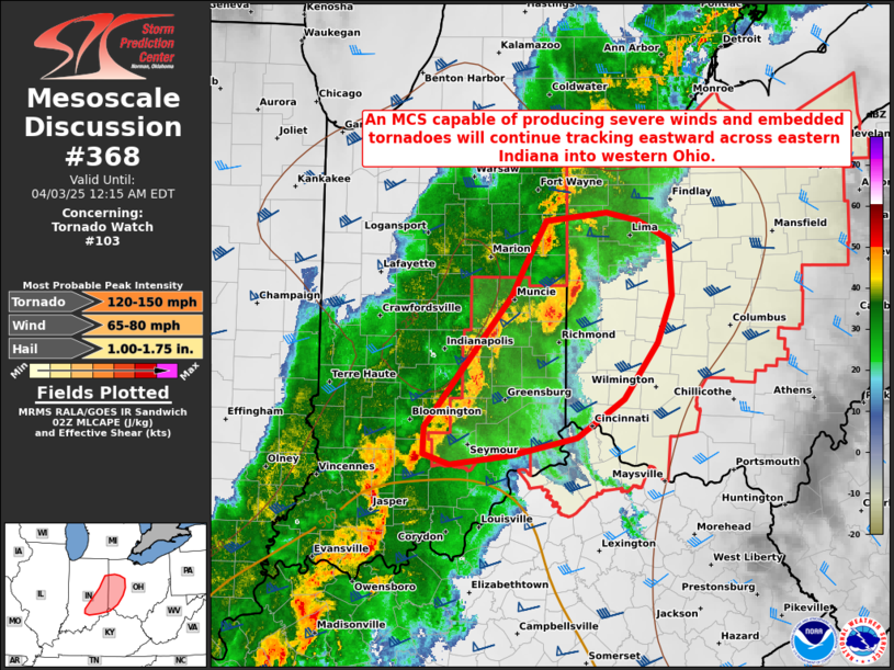
Mesoscale Discussion 0368 NWS Storm Prediction Center Norman OK 0946 PM CDT Wed Apr 02 2025 Areas affected...Eastern Indiana into western Ohio Concerning...Tornado Watch 103... Valid 030246Z - 030415Z The severe weather threat for Tornado Watch 103 continues. SUMMARY...An organized MCS capable of producing swaths of severe wind gusts and embedded tornadoes will continue tracking eastward across eastern Indiana into western Ohio. DISCUSSION...A NNE/SSW-oriented MCS (with embedded supercells) is tracking eastward across eastern IN into western OH -- with the northern portion of the line moving at 60 kt and southern part at 45 kt. This system has a history of producing destructive wind gusts and embedded tornadoes. Ahead of these storms, the ILN VWP is sampling an 80-kt low-level jet (at 2 km AGL), which combined with moist/unstable inflow (lower/middle 60s dewpoints -- higher farther south), should support its maintenance with eastward extent (especially the southern portion of the line where instability is greater). The primary concern with this activity continues to be swaths of severe wind gusts (generally 70-80 mph) and embedded tornadoes, given around 60 kt of 0-1 km shear/550 m2/s2 0-1 km SRH (per ILN VWP). With a west-southwesterly deep-layer shear vector, any NNW/SSE-oriented portions of the line will pose the greatest risk of severe wind and tornadoes. ..Weinman.. 04/03/2025 ...Please see www.spc.noaa.gov for graphic product... ATTN...WFO...ILN...LMK...IWX...IND... LAT...LON 39348417 39008469 38868540 38778609 38868637 39098637 40218541 40468526 40858503 40938436 40868401 40708367 40228364 39818379 39348417 MOST PROBABLE PEAK TORNADO INTENSITY...120-150 MPH MOST PROBABLE PEAK WIND GUST...65-80 MPH MOST PROBABLE PEAK HAIL SIZE...1.00-1.75 IN |
|
|
Top/All Mesoscale Discussions/Forecast Products/Home |
|
