
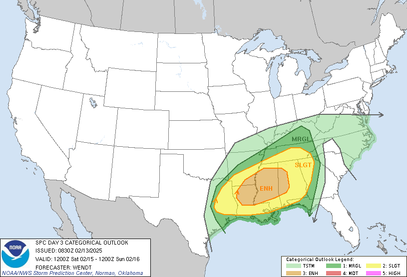
As of February 13, 2025, the Storm Prediction Center has issued a detailed Day 3 Severe Thunderstorm Outlook. This alert primarily affects parts of the Lower Mississippi Valley and western Alabama with heightened risks of severe thunderstorms. With predictions for damaging winds and potential tornadoes, this analysis will explore upcoming weather patterns and risk assessments, shedding light on what residents can expect.
As the southern United States braces for severe weather conditions, understanding these forecasts is crucial for safety and preparedness. With a significant cold front approaching, this post breaks down the essential elements of the outlook, the regions at risk, and actionable safety tips for affected populations.
Severe Weather Risks
Areas of Concern
The outlook highlights an enhanced risk for severe storms spanning from East Texas to much of the Southeast and Mid-South. The forecast emphasizes the following primary threats:
Damaging Wind Gusts: Scattered to numerous damaging wind gusts are expected, potentially impacting infrastructure.
Tornado Potential: A few tornadoes may occur, particularly in the afternoon and evening hours when severe convection is most likely.
Temperature and Atmospheric Conditions
Temperatures within the warm sector are anticipated to soar into the mid to upper 70s°F. The elevated heat, combined with favorable instability, significantly enhances storm development potential, especially as the environment becomes increasingly conducive for severe weather.
Meteorological Synopsis
Weather Patterns in Play
A robust upper-level trough is expected to sweep through the southern Plains and into the lower Mississippi Valley. As this system deepens, a surface low will move through the Mid-South and toward the Ohio Valley. The following meteorological factors will be critical:
Cold Front: A cold front will sweep across the southeast beginning in the late afternoon, aligning with the expected arrival of severe storms.
Wind Fields: Anticipated strong wind fields, with substantial low-level and deep-layer shear, support the potential for organized, severe thunderstorm activity.
Forecast Challenges
Current models show some uncertainty related to storm development, particularly in areas of East Texas and the Sabine Valley. While storms may be supercellular initially, the evolving thunderstorm state will be crucial in determining the severe weather characteristics as the day unfolds.
Regional Specifics
Lower Mississippi Valley
Specifically, areas like Jackson, MS and Tuscaloosa, AL fall within the enhanced risk zones, where the population density could exacerbate the impacts of severe weather. Routinely checking local alerts is crucial for residents in these regions.
East Texas and Sabine Valley
In East Texas, storm development shows higher uncertainty, yet the potential for activity could yield damaging winds and tornado risks due to strong shear in the region.
To stay informed on severe weather developments and safety procedures, consider subscribing to weather alerts or following us on social media for continuous updates.
In summary, the Storm Prediction Center’s outlook for February 15, 2025, indicates a credible threat for severe thunderstorms with significant risks for damaging winds and tornado activity. Residents of the affected areas are urged to prepare by reviewing safety guidelines and staying updated through local weather services.
To stay informed on severe weather developments and safety procedures, consider subscribing to weather alerts or following us on social media for continuous updates.