Tropical Weather Update: Monitoring Active Systems and Developing Conditions
Date: October 5, 2024
Source: National Hurricane Center
Greetings, weather enthusiasts. Here is the latest update on tropical weather conditions affecting the North Atlantic, Caribbean Sea, and the Gulf of Mexico.
Active Systems
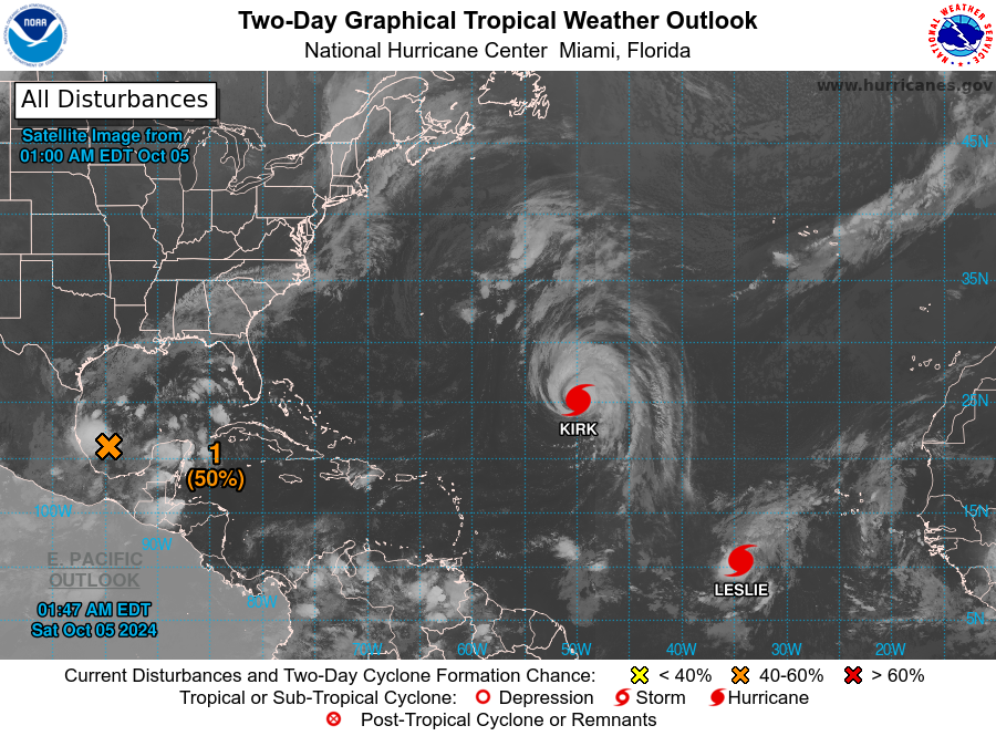
The National Hurricane Center is currently tracking two significant systems:
- Hurricane Kirk: Positioned over the central subtropical Atlantic Ocean.
- Tropical Storm Leslie: Located in the eastern tropical Atlantic Ocean.
Both systems are being closely monitored due to their potential impacts.
Gulf of Mexico Development (AL92)
Recent satellite data reveals an area of low pressure over the southwestern Gulf of Mexico. This system is broad and not well-defined but is producing winds just below gale force. There is a significant likelihood of development into a tropical or subtropical depression or storm over the weekend or early next week as it moves eastward or northeastward across the Gulf of Mexico.
Areas of Interest and Advisory:
- Yucatan Peninsula, Mexico
- Florida Peninsula and Keys
- Northwestern Bahamas
These regions should stay informed as the system progresses. Irrespective of its development into a tropical or subtropical formation, heavy rainfall may affect parts of Mexico over the next couple of days and much of Florida from late this weekend through mid-next week.
- Formation chance through 48 hours: Medium (50%)
- Formation chance through 7 days: High (80%)
Far Eastern Tropical Atlantic Development
A tropical wave is anticipated to move off the west coast of Africa early next week. While moving westward or west-northwestward across the eastern tropical Atlantic, some development is possible. The system is expected to approach the Cabo Verde Islands by mid-week. Those in the vicinity should keep an eye on its progression.
- Formation chance through 48 hours: Low (near 0%)
- Formation chance through 7 days: Low (30%)
Stay tuned for further updates, and ensure preparedness as these weather patterns unfold. Your safety is our priority.
Forecaster: Berg
