Tropical Weather Outlook
National Weather Service, National Hurricane Center, Miami, FL
Issued by the National Weather Service Weather Prediction Center, College Park, MD
2:00 PM EDT, Tuesday, September 3, 2024

For the North Atlantic, Caribbean Sea, and the Gulf of Mexico:
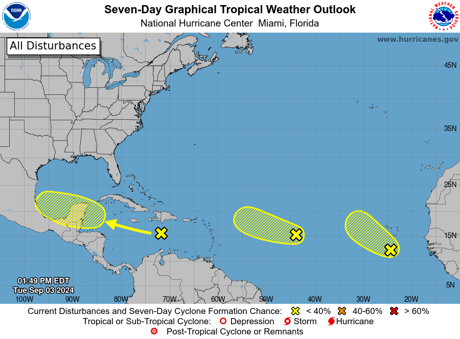
- Caribbean Sea:
A tropical wave is causing disorganized showers and thunderstorms over Hispaniola and parts of the central Caribbean Sea. As this system moves westward, some development is possible when it reaches the western Caribbean Sea and the southwestern Gulf of Mexico later this week or over the weekend.
- Formation chance through 48 hours: Low, near 0 percent.
- Formation chance through 7 days: Low, 30 percent.
- Eastern Tropical Atlantic Ocean:
A tropical wave over the far eastern Atlantic is producing disorganized shower activity. Some slow development of this system is possible over the next few days as it moves west-northwestward or northwestward across the eastern tropical Atlantic Ocean. Environmental conditions are expected to become less conducive by the end of the week. This system could bring locally heavy rains and gusty winds to parts of the Cabo Verde Islands in a day or two.
- Formation chance through 48 hours: Low, 20 percent.
- Formation chance through 7 days: Low, 30 percent.
- Central Tropical Atlantic Ocean:
Another tropical wave, located approximately midway between the west coast of Africa and the Lesser Antilles, is producing disorganized showers and thunderstorms. Some slow development is possible over the next couple of days as the system moves west-northwestward. However, by the end of the week, environmental conditions are expected to become unfavorable for further development.
- Formation chance through 48 hours: Low, 10 percent.
- Formation chance through 7 days: Low, 10 percent.
Forecasters: Bann/Cangialosi/R. Zelinsky
